


rachais Bastille

pmetayerign
User
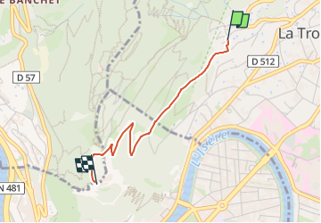

Length
2.3 km

Max alt
495 m

Uphill gradient
209 m
Km-Effort
4.5 km

Min alt
293 m

Downhill gradient
45 m
Boucle
No
Creation date :
2025-04-09 06:34:12.782
Updated on :
2025-04-09 06:34:13.808
1h01
Difficulty : Easy

FREE GPS app for hiking
 SityTrail
IGN / Geographical institutes
SityTrail Plus
The world is yours!
About
Trail Walking of 2.3 km to be discovered at Auvergne-Rhône-Alpes, Isère, La Tronche. This trail is proposed by pmetayerign.
Description
Bastille par chemin du côteau
Positioning
Country:
France
Region :
Auvergne-Rhône-Alpes
Department/Province :
Isère
Municipality :
La Tronche
Location:
Unknown
Start:(Dec)
Start:(UTM)
714956 ; 5009768 (31T) N.
Comments